IW AONB Map
Walking and Cycling
The Isle of Wight AONB is packed full of magical landscapes, stunning views and vistas, wonderful wildlife and a rich and varied heritage. We believe that the best way to enjoy these treats is by foot or pedal. To help point you in the right direction we’ve collected together guides to some of our favourite walking and cycling routes.
New guides and walks will be added to this page on a regular basis so you’ll never be short of something to do or somewhere to explore the Island’s finest landscapes.
Osborne Coast
Rambles by Bus
- Pier to Creek– 3.6 mile walk between Ryde and Wootton
Central and East Downs
Easy Access Walks
- Alverstone– Easy Access walk around Alverstone Mead & Youngwood Copse Nature Reserves
National Trust Walks
- Borthwood– 1.25 mile circular squirrel spotting walk
- Bembridge Fort & Culver Downs– 2.75 mile circular walk
Rambles by Bus
- Sandown to Bembridge – 4.7 mile walk
South Coast and Downs
Isle of Wight AONB Walks
- Undercliff and Downs walk
- Worsleys, Wyverns and Appledurcombe
National Trust Walks
- Luccombe & the landslip– 4.5 mile circular walk
- Ventnor Downs– 2.6 mile circular walk passing sites of Pre-History to Cold War
Rambles by Bus
- Pier to Creek– 3.6 mile walk between Ryde and Wootton
South West Coast and Downs
Heritage Trails
- Poets, Painters, Pioneers and Polymaths – a circular 4 mile walk around the haunts of Freshwater’s Victorian Celebrity Circle
- Robert Hooke Trail – a circular walks around locations associated with the life of the 17th century scientist, Robert Hooke
- Where Dinosaurs Roamed – a scenic circular walk along the island’s ‘Dinosaur’ coast.
Easy Access Walks
- Tapnell Trail– an accessible 6.5 mile walk in open countryside and the slopes of the downs
- Western Yar Estuary– an accessible 3.8 mile walk around the Western Yar Estuary
National Trust Walks
- Compton Bay Downs Walk– 8 mile circular walk along Afton, Brook & Compton Downs
- Compton Bay Butterfly Walk– 5 mile circular walk looking for butterflies on the Downs
- Chillerton Down– 9.25 mile circular walk in middle of the Isle of Wight
- Headon Warren– 4.25 mile circular walk from Totland to Headon Down
- Mottistone south to the sea– 2.75 mile circular walk
- Mottistone climb to the common– 4.25 mile circular walk
- St Catherine’s Down– 4.8 mile circular walk taking in The Hoy Monument
- St Catherine’s Down –75 mile circular walk passing Knowles Farm & St Catherine’s Lighthouse
- Tennyson Down – 7 mile circular walk from Highdown Chalk Pit to Farringford via the Needles
Rambles by Bus
- Discovering Dinosaurs– 9.3 mile linear walk between Compton Bay and Chale
- Towering Tennyson– 4.4 mile walk around western tip of the Island
- Warrior Trail– 5.7 mile walk around Mottistone & Brook taking in part of the coastal path
North West Coast
Heritage Trails
- West Wight’s Sunken Secrets – a walking tour of the fascinating shipwrecks of the West Wight
- Taste the View – three walks exploring the relationship between food and the landscape
- Walk the Forts – a scenic circular walk around the coastal defences of the West Wight
National Trust Walks
- Newtown– 4 mile walk around the National Trust’s National Nature Reserve
Rambles by Bus
- Solent Coast– Rambles by Bus – 7 mile coastal walk between Yarmouth & Ningwood
Dark Skies
Dark skies are special areas where there are low levels of light pollution. When there is an absence of light pollution thousands of stars are revealed at night. This is beneficial to the wildlife and tranquillity of an area. The Isle of Wight has a high quality of night sky; this is especially apparent within Wight AONB – a great place for Dark Wight Skies.
Viewing Dark Skies is best done on a clear night when the sun has completely set and there is no moonlight. Even better is to find an area where there is very little artificial light. Some of the best locations are found on the South Western Coast of the Isle of Wight along the Military Road. However, there are places across the Island that can boast Dark Skies.
Vectis Astronomical Society in partnership with Wight AONB are currently researching the quality of the Isle of Wight’s Dark Skies. To see where the darkest areas are please visit the SQM Map which shows the most recent readings of the Sky Quality.
The AONB Partnership considers the Island’s dark skies to be an economic as well as a cultural and scientific asset, which makes a valuable contribution to tourism by attracting people to the Island as well as for the enjoyment of residents.
For more information please download the IOW AONB Dark Sky Guidance
The Campaign to Protect Rural England (CPRE) has been a stalwart champion for the protection and improvement of dark skies, and against the spread of unnecessary artificial light. Having last published a major mapping project on light pollution and dark skies in 2003 (based on data from 1993 and 2000), CPRE commissioned LUC to create new maps of Great Britain’s light pollution and dark skies.
Using data captured by a satellite at 1.30 am throughout September 2015, the latest technology has been used to give an accurate picture of how much light is spilling up into the night sky and show where urgent action is needed. We also sought to find where the darkest skies are so that they can be protected and improved. For more information please visit: http://nightblight.cpre.org.uk
Landscapes
The extraordinary diversity of the Isle of Wight landscape is both its strength and its vulnerability. No other part of England has this small-scale, intimate landscape, which changes so quickly from wild and rugged to green and lush. Yes, there are big vistas that fill the postcards: a sunset from Blackgang Viewpoint; the Needles from Headon Warren; the eastern Solent from Ashey Seamark. But these are just a few headlines from this fascinating story and to truly appreciate the whole, one needs to pore over the detail.
The Isle of Wight AONB comprises a multitude of character types here are some of the most exciting:
Farming in Protected Landscapes
Farming in Protected Landscapes in Isle of Wight Area of Outstanding Natural Beauty The Defra-funded Farming in Protected Landscapes programme will be open for applications
UNESCO Sites Across the Channel – Interreg Project
UNESCO Sites Across the Channel A new model of sustainable tourism We are thrilled to announce a new project to further develop sustainable tourism opportunities


Soft Cliffs & Chines
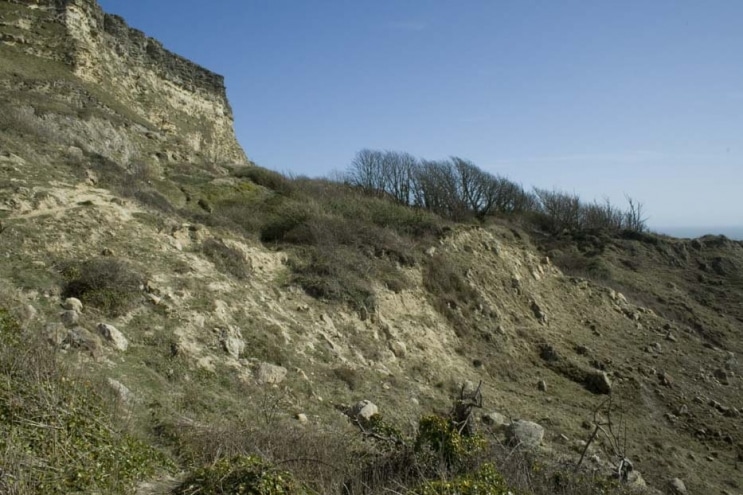
The cliffs on the south side of the Island are prone to slumping and this process of erosion is very important for the wildlife that lives in this exposed area.

Sandy Hills
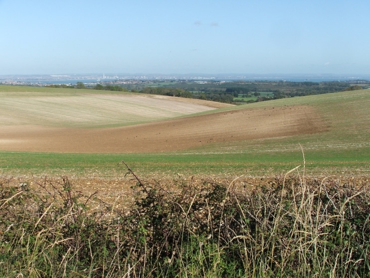
Sandstone hills and gravel ridges are found in small areas south of the main chalk ridge which runs along the middle of the Island.

Rocky Cliffs
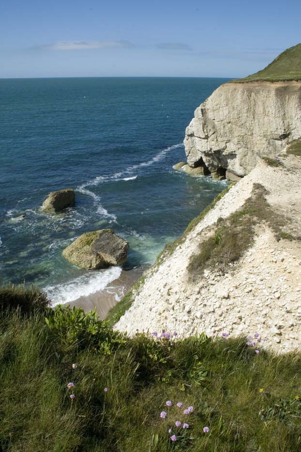
The Island’s remarkable geology is easily visible where the sea has worn away coastal rocks.